


Initial survey of unknown complex settlement in the valley of Chkhere river in Stepantsminda, Greater Caucasus, Sakartvelo.
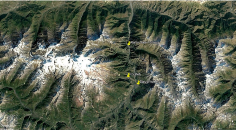
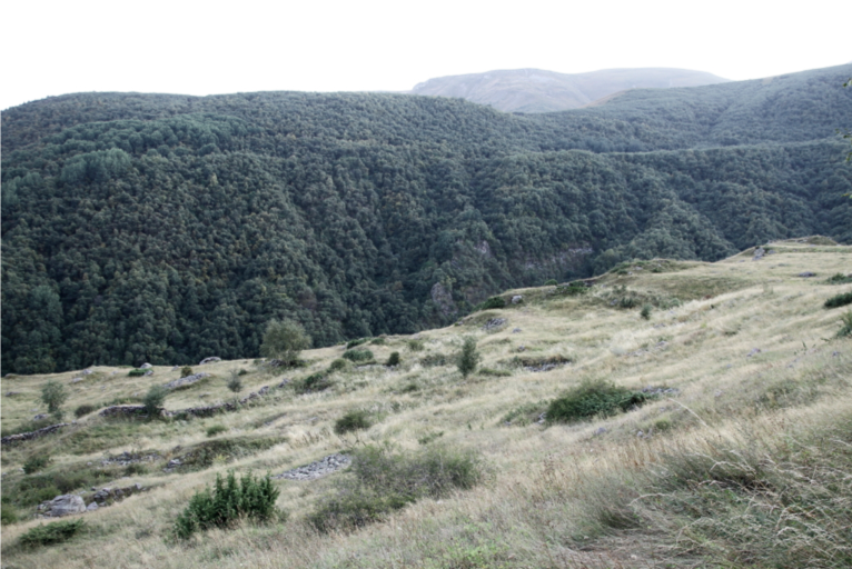
During several weeks of 2017 and 2018 team of Kazbegi Archaeological Survey[1] conducted by the author undertook the preliminary, archaeological survey of the site located two kilometers to the NW from Gergeti village, on western peripheries of Stepantsminda town, most northern immense settlement in Khevi region, in Greater Caucasus, Sakartvelo/Georgia (Fig. 1). The presented location was noticed by the author in 2015 during walk from Chkhere valley to Tsdo village. Proximate site localization to Dariali Gorge and its topography carrying the pattern of immense artificial modifications, brought idea of possible site significance [Makalatia, 1934: 13, 22, 25, 35 – 37, Mindorashvili 2005: 176 - 179, Galichian, 2007: 17, 18; Gagoshidze I. 2008: 9, Rayfield, 2012: 17,24-25,32-33,59,63,90-91,123,137, Sauer… 2016: 18-24,] . Later participance in the excavations of various sites in Dariali Gorge[2]and gained deeper knowledge regarding archaeology and history of Central Caucasus, only consolidated these assumptions. The revealed plot was surveyed on the limited scale (top and foothill) by field walking and basic recording following the single context recording methodology including photography, note taking and recording GPS coordinates [Anderson… 2014: 13-14]. Such undertaking exposed clearly seen evidence of an intricate settlement. Unfortunately, the chronology of recorded features cannot be precisely established at this stage of research. None of dating artefacts have been collected from the surface[3]. The site of interest lies roughly in the middle of E – W orientated valley of Chkhere river, left tributary to Terek river[4] (Fig.1). The solid geology of the described location has a volcanic character. Uppermost levels of site stratigraphy are coated by layers of the mountain meadow soil, overmixed with the sorted lithic material collapsing from craggy sides soaring over the site to the north, from where also came several boulders spotting terraced
|
Fig. 1. Localization of study site Kolsteti. After Google Earth |
flat surface.
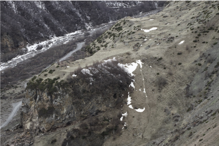
The semi–isolated hill where the site is located, sharply rises its cliffs up to 35 meters high from the bottom of the valley. The site is partly attached on northern side to the slopes of Chkhere river valley. South, south–east and part of northern section of the site has edges limited by rocky cliffs vertically dropping down from the one-third of the slope. The shape of the site can be described as linearly irregular, naturally curved into a kidney–like form (Fig.2; 3). Western side in one - third following the valley’s cardinal form, then bends south–east developing into the quadrilateral peninsula, closely pointing to the opposite side of Chkhere valley establishing narrowed section of the river canyon. Along the forefront side of the hill, runs the rocky shelf rising from the base of the valley diagonally girdling northwards. The described step ends on the precipitous adjacent slope of eastern exposition[5]. At the base of cliffs, are the caves noticeable even from distance. Two biggest niches adopted into shelters still being in use by pastoral activity are in SE and SW side of the foothill.
Topography of the discussed hilltop is complex, carrying natural forms as well as the pattern of the artificial modification (Fig. 2; 3; 5). By means showcased above, the boundaries of the site are very clear, in most parts limited by sharply dropping edges nevertheless on the side attached to the valley slants, the site limits becoming unclear. Establishing northern border, roughly above highest readable archaeological features, may change in future[6]. Most legible is difference in high between western part of the site and its peninsular eastern terminus. Respectively, elevation vary from approx. 1973 to 2020 m asl[7]. The terraced plateau of the site is 272 m long. Its SE terminus is 39.2 m and SW 23 m wide. The top of the site can be reached from reverse sides. However, the main, most comfortable eastern path, carrying signs of long-time usage and crosses mentioned below source of fresh water. The nearest water body to the top of the studied hill is located around one hundred meters NE. This is a small spring flowing southward to the slopes of the valley and crossing the eastern access route leading to the hilltop. There is a possibility that in the past, water spring existed also within the site limits, albeit survey had not established its presence. Chkhere river meandering not more than fifty meters south to the base of the studied hill. However, the water curse and the riverbed was shifting very often. The hilltop is covered by grassy meadows used for animal grazing and autumn hay – making. South – eastern part of the plateau, where the ground rises, is overtaken by the birch trees growing in small concentration. The sharp north – east slope of the site is partly covered by the birch copse too. The thick conifer shrubs are growing in the remains of the stone
|
Fig. 2. Chkhere hilltop seen from the east |
masonry features across the studied localization.
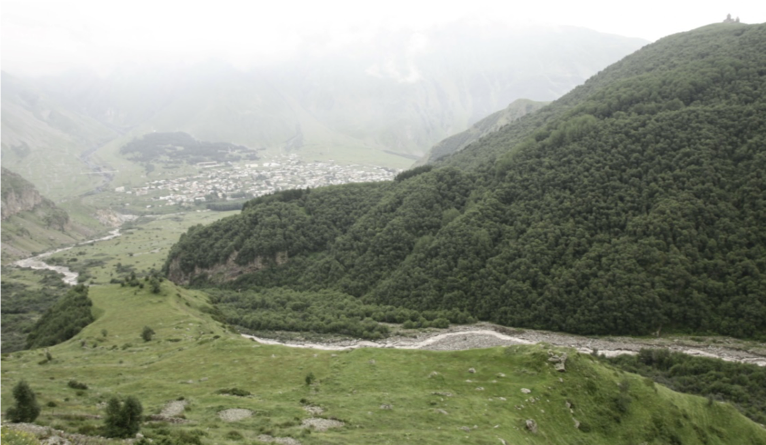
There are several toponyms linked with presented localization. The local people call the studied hill KOBI/KUOBI or KOLSTETI[8]. The first two words have almost the same meaning and can be translated as cauldron nor feature reminding its shape yet anything of concave, becoming deeper form (Fig. 2; 3). Worth to say is that at the same time those words in old-fashioned Kartuli (Georgian) describing cave [Mchedlishvili…2008]. Another expression connected with the presented site known in local tradition is KOLSTETI. It seems that this term does not have any meanings in known Georgian. Possibly, it is related to the north Caucasian tongues. Correspondingly, the survey team recorded likewise too that also exists additional word SAGULABELI, which match considered location. However, depicts only topographical feature, existing in close vicinity to the site. Sagulebeli can be understand as a spot where people are keeping over the winter dry hay harvested usually during late autumn and storing it http://www.nplg.gov.ge/gwdict/index.php?a=term&d=8&t=47718 in small heaps secured against decomposing [Mchedlishvili…2008]. This is also the place free of snow slides, safe storage, naturally occurred in a landscape shelf or depression. Such a place exists on the slope, approximately 50 meters over the
|
Fig. 3. Kolsteti hilltop. View from the west. In top right corner Gergerti Sameba Church and Stepanstminda town to the left. |
western part of the site[9].
So far the undertaken evaluation confirmed that there are not written known sources mentioning the study site under any of the names citied above. However, local tradition memorized the factual history of the thriving settlement in post medieval times, even names of families are acknowledged. According to director of Stepantsminda Historical Museum, I. Kazalikasvili, the terraced village located at the top of the studied hill has existed since the late sixteenth/early seventeenth to the late nineteenth century.
First, the brief visit on site in 2016 came out with confirming, noticed from distance one year earlier, land modification in the form of terraces, mounds and surface flattening. The curved, semi regular outline of the presented localization as well as the solid difference between the site highs has limited usage of the hilltop. However, the space management of the entire plot was efficient and well–matched natural topography. There are distinguished seven terraces of dissimilar size. For needs of research, the studied segments were numbered in order from one to seven starting from the highest, western terrace. Terraces #1 and #2 are practically of an identical rectangular shape and size 31 m x 22 m. Central terraces #3 - #6 are of more limited dimensions what is dictated by the local topography, where the hilltop bends transforming into the jetting peninsula and exposition of the slope becomes a supplementary tilt. The greatest is the lowest terrace #7, orientated SE – NW, occupying whole length of the peninsular site segment with its 39.2 m of maximum width and 73 m of length (Fig.2; 3). The adjacent, northern side of researched localization has not an evident presence of a surface modelling except of SE section, where occurs the platform connected to the existed stone masonry remains.
|
Fig.4. Stone masonry structure within the mound. SW of terrace nr 1. |
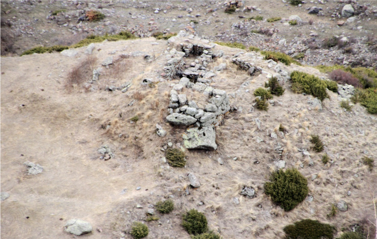
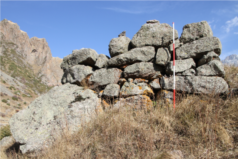
The presence of features related to a broader scope of earthworks were noticed. The clearly seen mound in SW corner of terrace #1 is presumably artificial one linking to the construction of the stone masonry structure within it (Fig. 4; 6). This regular, roughly L – shaped tell with dimensions of 15 m x 15 m x 5 m has the highest point rising 3m over the flat terrace level. The described mound accommodates the architectural remains formed into two segments. The main, highest one of N-S orientation and the lowest, adjoining E – W orientated segment. Next, off the ground rising deformation with similarities to pointed above, is the bank located in SE angle of terrace #2. 2 m high embankment has a linearly rectangular, westward decreasing form. Its longer EW side stretches for 14 m, shorter SN is 5 m wide. The perceptible outline of the stone masonry structure has been recorded atop. Another ground embankment rises on the southern side of platform #3 and without doubt is related to the construction of the building partly preserved in its lowest sections (Fig. 5). Not clear is the origin of the most significant barrows in SE part of terrace #7. At this state of research, the author is unable to define whether those objects are of an archaeological nature or not, though author has recorded presence of several smaller mounds in vicinity. This feature has been marked by the incorporating unworked stone onto their top. There were also noticed the concentrations of partly buried, roughly hewn stones along most southern and higher part of the depicted embankments. What comes as doubtful at this state of research is existence of the linear ramparts along edges of debated terrace #1.
In addition to the revealed archaeological features deliberately connected with much larger ground works are the cut features remodeling the site surface. One of them is the possible main cause way linking the uppermost site segments with the lowest terraces or even the bottom of the valley. Being unable to deliver an air photo material, the author studied only the available pictures and assumed that there could be the linear cut running along the northern side of the site acropolis. The further mitigation within the field survey, partly confirmed this theory through finding the corresponding cuts into the stepped limits of terraces[10]. The site examination also delivered different features matching the category of the immense surface remodeling (remains of stone lined cellars, ground cuts corresponding with outline of
|
Fig. 5. Central part of Kolsteti site and visible mounds 1,2,3 (from right to left) along southern edge of the hilltop. Terraced surface carries signs of intensive remodelling. |
unknown features) and these will be discussed below.
One of the most significant outcomes of survey is revealing architectural remains across almost whole site. The recorded relicts survived mostly in the lowest section as the outline of the stone build walls. There is a variety of architectural forms discovered. However, the most common are square or rectangular buildings. Very interesting and first of better preserved (1.80m high walls) is the structure within the mound in SW corner of terrace #1. The construction located here consists the rectangular (4.50m x 4.50m) room with the semi bowed northern side. The walls are of 0.85 m thick, build of large, roughly hewn stones set on naturally occurred boulders nor bedrock (Fig.6). Below the depicted structure, in N slope of tell, two stone lined niches have been discovered[11]. Adjacent to the S room (9m x 8m), has been divided by the thicker (0.60m) wall constructed of the smaller, mostly flat stones (wall possibly has later date than most of the complex)[12]. 8 meters long NS wall, running on the Eastern side, has complex 1 m thick structure with the hollow, square channels recorded on its terminus, where 1 m wide entrance existed. Partly backfilled by stone rubble, the neighboring room to the E, has regular square form (5mx5m). This is the lower side of the structure, constructed on the rectangular earth platform. Beneath the debated building remains steep SW ridge carrying the pattern of artificial remodeling. On its W side two courses, in the ground set masonry were found.
Following the same pattern of localization, along southern edge of the site, atop of the embankment in SE corner of terrace #2, the structure build of stone blocks existed. The closer examination revealed the alignment of two courses of roughly worked ashlars organized in stepped, platform like structure. In slopping eastwards section, between the steps, the stone lined cellar exists. However, its coverage by the dense conifer shrub makes the examination impossible. On platform #3, directly beneath the highlighted feature, the ruins of the stone building were recorded. The room of great dimensions (5.50 NS x 6.70 EW) represents the second, best preserved stone masonry structure, without immense quantity of stone rubble in the interior. The standing walls preserved from 0.40 m to 1. 20 m high. They were constructed of roughly hewn stones, sometimes incorporating blocks in size well over 0.70 m long and 0.50 m wide. Thickness of walls is likewise impressive, E one is 1.20 m and S 1.60 m thick. For purpose of construction mentioned structure, contactors erected the earth rampart to reinforce NS running the eastern wall as well as cut into side of the terrace due to construction of the western, NS running wall. In northern part of #3 terrace, the second stone cellar is located. The high, dense shrubs and its complete backfilling by masses of loose stones make recording complicated[13]. In the same state of preservation is most of the noticed stone lined cellars. Yet, in southern edge of platform #5, the outline of the deliberately well-sized cellar is barely noticeable. This feature is likewise full of stones, though the edge of the southern wall
|
Fig. 6. Western, fine preserved wall of building in SW on terrace nr 1. Photo scale – 2 m. |
and NW corner stones are perceptible.
All examined stonework carry the same model of similarities. These structures have been erected according to an analogous technique which can be described as ‘’ dry wall’’ what means that no bonding material have been used[14]. The stones forming the wall were skilfully selected and laid (Fig. 6). In one case, advanced architectural solutions were incorporated – the parallel slots inside NS running higher wall of building on #1 terrace. The building material has local origin and this is only stone. The stonework gives impression of usage just roughly hewn blocks, none of deliberately advanced carved stones have been recorded. Remained parts of architectural structures have not delivered any strong dating evidence as masonry marks, well dated stone shaping or so. Survey revealed nine architectural relicts of the same rectangular form. Build in-ground, free standing structures, are mostly located on the terraces in central, bending part of the hilltop. Origin of the structure recorded in most northern edge of platform #1 and in SE corner of #2 platform, is hard to define. However, according to the local sources, the structure existed in SW of platform #1, was of sacral function serving as the chapel for inhabitants of Kolsteti[15].
Among the discovered features are less evident outlines of fewer structural remains. By this, the author means the visible arrangements of stones along with ground modifications, presumably connected to different phases of settlement and landscape management. Variety of such remnants may be divided into two groups where one category will host, in ground preserved features, seen only from higher distance. There are several features falling into this category across the researched hilltop. However, terrace #1, in area northward and westward of the chapel ruins seems to be densely altered. Another group is represented by on-ground outlined features, highlighted by presence of stones congregated in close distance. Again, one of the areas where at least such an object can be found is terrace #1. Feature occurring in south west section of terrace #2 may carry similarities. The discussed structure has been manifested by presence of 4 unworked boulders, placed on the edges of flat depression. NS oriented edge to the west, has been marked by one stone placed next to the side of E facing terrace step. 3 stones remain in EW oriented line along gently sloping edge of higher part of terrace #2[16]. Not limited by standing stones, southern side runs along the sloping limit of the site. Though, partly buried in the ground sub circular flat stone, rests opposite the stones forming NS linear arrangement. Without doubt most interesting in this category is the vast feature documented in SW part of terrace #7. The shape of the discussed object can be noticed after a closer examination of several boulders positioned in an organized manner. Roughly rectangular, with wider curved western side narrowing eastwards, feature stretches for 20 m EW x 7m SN. The stones have been again deliberately arranged along the edge of the flat ground deformation clearly readable as the platform. Its eastern edge forms the entrance lined on sides by stones following edges of kind of the entrance platform 3.20 m wide and 6 m long. Sarsens of locally occurring rocks used to form the depicted feature are of various sizes and shapes, most bigger ones forming western part, are separated by unequal distance.
Mentioned above, outlined features sharing suggestive similarities allowing to say that those structures are analogues. This apply particularly to the object from terrace #2 and #7. The structures share a comparable localization in SW corner of the terrace, ground remodeling and yet similar layout arranged according EW axis and structure formed of boulders. Presence of carved stones in close vicinity also suggests a kind of physical pattern.[17]
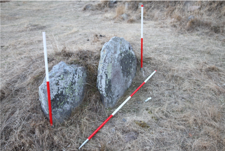
The survey of Kolsteti hilltop revealed the group of five, possibly carved stones not clearly related to construction of obvious architectural features or any other known purpose. Those objects were noticed on terrace #1, #2 and terrace #7. There are clear to distinguish, multiple marks of stone curving. Examination of studied rocks allowed to say that there could be at least two main ideas of stone shaping. In the first case, this is a group of three rocks with improvements creating edges formed into step or semi straight angle. The following trend has exclude three stones taking a shape of slab, on this account, two of such stones standing collectively being vertically set in the ground (Fig. 7)
|
Fig. 7. Two standing slabs located in NE part of platform 2. Photo scales – 1 and 2 m |
This report summarizing the closer inspection and inventory of heritage monuments at Kolsteti/Kobi hill top. Survey undertaken on the study site is scoped for purpose of the further research. Confronting existing hypothesis in regard of age and function kept by the study site must finally lead to excavations. Coherent enough, brief assessment undoubtedly marked an immense potential of this marginal settlement. By its localization and topographical values, Kolsteti was incorporated into a pastoral landscape exploited by the inhabitants of Gergeti village and Stepantsminda town[18]. Nevertheless, it is very hard to decline human presence in the earliest periods. The communication passage leading Asia and Europe running along the course of Terek river and the open valley hosting Gergeti village with Kazbegi town as the closest advanced dwelling is one of the factors of the greatest importance for the study site. Early medieval Bethlemi Cave shrine as a monastic settlement nestled on the eastern slopes of Mkinvartsveri mountain (possibly predated by pre-Christian shrine), later existence of Gergeti Sameba Monastery and vibrant development of Gergeti village were predated by thriving Bronze Age settlement in the Terek valley, then later, located in Dariali Gorge multi-cultural centre of power guarding transcontinental route. Alan’s/Caspian Gate fortress situated in the narrowest section of claustrophobic Dariali, had fundamental strategic values desired by rulers keeping throne in Persepolis, Rome, Constantinople, Ctesiphon, Baghdad and capitols of Eurasian Steppe.
Reading Caucasian monumental landscape makes a reader always busy. However, very often verses are unclear and becoming blurred by distance of time or unknown cultural habits vanished due to curse of times, very often dotted by struggle of entire societies, this smaller occupying valley or those forming entire nation. Past of Kolsteti echoing in the shape of relicts of terraced settlement making this localization extraordinary. At the same time, construction of new road all the way along Chkhere valley, up to the monastery over Gergeti village, put on risk detected heritage and without appropriate undertaking, undefined historical monuments can be destroyed[19]. The main goal of the presented project is creating data base of unknown features endangered by a fast development in the region. Extremely rich heritage may be soon destroyed by alarming state of ignorance upon creating any sort of transparent policy and management of historical matter.
[1]An independent research project gathering survey data of previously unknown areas. Author is grateful for participance and helpful assistance of college PhD candidate N. Janashvili from Georgian National Museum.
[2] Within broad project “Persia and its neighbour’s ‘’ supervised by Prof Eberhard Sauer from University of Edinburgh.
[3] Several pottery sherds have been found along upper part of access route. These fragments are of possible Early and Late Medieval provenience. After Erakle Koridze from Georgian National Museum.
[4] Chkhere river begins by the front of Abano and Ortsveri glaciers, in dramatically deep U – shaped valleys on eastern slopes of Mt. Mkinvartsveri/ Kazbeg (5047m asl), approximately three kilometres west of the Site.
[5] Form and localization of this feature reminds partly preserved manmade access route possibly destroyed by slope slide. However, this though requires future consideration.
[6] By this, author means architectural remains in form of stone masonry cellars noticed in southern part of northern adjacent slope and highest possibly worked boulders in western, most upper part of the Site.
[7] Estimated elevation carries uncertainty caused by usage of simply hand hold GPS device of doubtful calibration capabilities.
[8] Words of thank you to Iago Kazalikashvili – director of Stepantsminda Historical Museum for sharing his precious knowledge.
[9] Author concludes that depicted terrain feature has less likely natural origin. Survey of areas above Kolsteti recorded several forms of manmade alternations of natural landscape.
[10] Edge of Terrace #1 has cut roughly in the middle, just below it, kind of rampart exists. Precipitous step of terrace #2 has wide sloppy cut on its northern terminus. Further outline of highlighted feature becoming blurred continuing eastward.
[11] Currently overtaken by shrubs.
[12] According to the local history, around XIX c, after bloody revenge, one of the family have been exiled from Stepantsminda and settled in Kolsteti choosing discussed structure as their home.
[13] Possibly assembled during field Clarence but without doubt previously forming standing walls.
[14] Spot dating and establishing chronology of this kind of masonry is not easy due to continuous usage of the same building techniques for centuries. Nevertheless, lowest age of studied relicts falls into Early Medieval and latest around High Medieval. K. Digmelashvili from Georgian National Agency for Cultural Heritage Preservation consider Early Medieval provenience of studied features.
[15] After Iago Kazalikashvili.
[16] Further north east, one stone exists (second carved stone), but possibly does not belongs to described feature
[17] Words of thank you to PhD Anastazja Chizhova, PhD Aneta Golebiowska – Tobiasz and Phd Dmitri Korobov for further interpretational possibilities.
[18] Chkhere valley have been partly surveyed in 2013 by joint research team from Tbilisi State University and Durham University within research project “Persia and its neighbour’s ‘’. Great words of thank you to Kristen Hopper (DU) for kind approach and informative consultations.
[19] Author and his team have contacted in late 2017 Georgian National Agency for Cultural Heritage Preservation in purpose of registering Kolsteti as protected by law archaeological monument.
References
| Anderson W., Birkett-Rees J., Negus Cleary M., Krsmanovic D., Tskvitinidze D. 2014 |
Archaeological Survey in the South Caucasus (Samtskhe – Javakheti, Georgia): Approaches. Methods and First Results. Anatolia Antiqua. XXII. |
| Galichain R. 2007 |
Countries South of the Caucasus in the Medieval Maps. Armenia, Georgia and Azerbaijan. London. |
| Gagoshidze I. 2008b. |
Kartli in Hellenistic and Roman Times. General Aspects. In Furtwängler, A., Gagoshidze, I., Löhr, H. & Ludwig, N. Iberia and Rome: The Excavations at the Palace at Dedoplis Gora and the Roman Influence in the Caucasian Kingdom of Iberia. Langenweißbach. |
| Makalatia S. 1934 |
Khevi. Tbilisi. |
| Mindorashvili D. 2005 |
Archaeological Excavations in Khevi. Tbilisi. |
| Mchedlishvili D. 2008 |
Kuabi. National Parliamentary dictionary in Georgia. Tbilisi – Kutaisi. http ://www.nplg.gov.ge/gwdict/index.php?a=term&d=8&t=47718 |
| Sauer E. W., Chologauri L., Naskidashvili D. 2016 |
The Caspian Gates: Exploring the most famous mountain valley of the ancient world. Current World Archaeology. |